Joseph Belard Hunt
Settler of township lots: Lot 26, Conc. 9, Stanhope
Link to the Hunt family on the Settlers of Algonquin Highlands family tree website
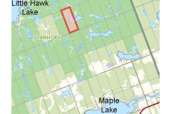
Location: Map point is the approximate location within this 101 acre lot which is three lots north of the west end of Barry Line Road
Land acquisition:
- 1876 Lands Liable to Taxation: Township of Stanhope Register - 101 acres assessed to Joseph B Hunt
- 1876 Crown Land location certificate - 6 Nov 1876 - Joseph Bellard Hunt of the township of Stanhope, age 19
Dates of residency:
- 1907 Death of daughter Mary Jane Hunt at Lot 27, Conc. 6, Stanhope
- 1911 Census of Canada, Stanhope: Joseph & Mary C Hunt at Lot 29, Conc. 5 which at this date was owned by Benjamin Sawyer. Ontario Land Parcel Register Book - Stanhope Concession 5 (Image 278).
- 1921 Census of Canada: Glamorgan with brother
- 1930 Death: Tory Hill
Interesting facts:
Miss Harriet Wyatt married John Robert Hunt (brother) in 1878 and set up housekeeping at Fourth Lake; their daughter was the only white child to be born at the ill fated settlement. One after another, families abandoned the struggle at Third and Fourth Lakes and moved away including the 3 Hunt families. Source: In Quest of Yesterday by Nila Reynolds. Published by The Provisional County of Haliburton, Minden, Ontario 1973 pgs. 320 & 321.
HIs father, John William Hunt, is listed at Lots 27 & 28, Conc. 8, Stanhope on 1876 Lands Liable to Taxation: Township of Stanhope register - 101 & 101 acres to John William Hunt. These lots were never patented. His map point is the approximate location within Lot 27, Conc. 8 which is one lot north of the west end of Barry Line Road east of Alpha Lane in the same remote area.