John Robert Hunt
Settler of township lots: Lot 27, Conc. 9, Stanhope
Link to the Hunt family on the Settlers of Algonquin Highlands Family Tree website
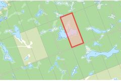
Location: Map point is the approximate location within Lot 27, Conc. 9 which is two lots north of the west end of Barry Line Road east of Alpha Lane
Land acquisition:
- 1876 Lands Liable to Taxation: Township of Stanhope Register - 101 acres taxed to John B Hunt
- 1876 Crown Land location certificate - 17 Oct 1876 - John Robert Hunt of the Township of Stanhope, age 27
Other locations: Lot 13, Conc. 9: 1893 & 1899 Stanhope Directory - Hunt J. R. Boskung. Lot Closed according to Ontario Land Parcel Register - Stanhope Concession 9 (Image 148).
Dates of residency:
- 1878 Marriage: Harriet Wyatt(1848-1912) Minden Twp
- 1879 Birth of Daughter Harriet Gertrude Hunt (1879–1905) Stanhope Township
- 1881 Birth of Son Ernest Walter Hunt (1881–1947) Haliburton
- 1881 Census of Canada, Barrie
- 1901 Census of Canada, Snowdon
- 1911 Census of Canada, New Westmister, BC
Interesting facts:
Miss Harriet Wyatt married John Robert Hunt in 1878 and set up housekeeping at Fourth Lake; their daughter was the only white child to be born at the ill fated settlement. One after another, families abandoned the struggle at Third and Forth Lakes [Cameron Lake Settlement Area] and moved away including the 3 Hunt families. Source: In Quest of Yesterday by Nila Reynolds. Published by The Provisional County of Haliburton, Minden, Ontario 1973 pgs. 320 & 321.
Preceding landowner: The Crown
Succeeding landowner: None - still Crown Land