George Alexander Masson
Settler of township lots: Lots 21, Conc. 3 & 4, Stanhope.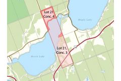
Location: Map point is the approximate location within 100 acre Lot 21, Conc. 4 on the north and south shore of the channel between Beech and Maple Lakes east of McPhail Road west of St. Peters Road.
Land acquisition:
- 1863 Lands Liable to Taxation: Township of Stanhope Patent Register - 66 & 100 acres to George Masson.
- 1863 Patent from The Crown. Ontario Land Parcel Register - Stanhope (Lots 21, Conc. 3 Image 376; Lot 21, Conc. 4 - Image 253)
Other land:
- Lots 9 & 10, Conc. 1, Stanhope.
- 1867 Lands Liable to Taxation: Township of Stanhope Patent Register. 94 acres in 1866 to George A Masson.
- 1866 Patent from The Crown. Moorefield Acres Ontario Land Parcel Register - Stanhope (Lot 9 & 10, Conc. 1 - Images 82 & 102)
Dates of residency:
- 1859 An early Stanhope pioneer. Source: 1871 Peterborough County Directory
- 1861 Census of Canada, Stanhope: George A Mason Age 27, Indian trader and Elizabeth Age 24
- Lot 21, Conc. 3, Stanhope - East of Redner Road on both sides of Hwy 118:
- 1871 Masson sold to Richard Henry Dawson
- 1881 Census of Canada, Stanhope: Mrs. Peter (Jane) Dawson 1816; Peter died in 1873 & Stephen 1852 & Richard 1850
- 1911 Census of Canada, Stanhope: Richard Henry Dawson - Lot 21, Conc. 4, Stanhope – St Peters:
- 1861 Agricultural Census Minden and Stanhope: 200 acres
- 1861 Census of Canada, Stanhope: George A Mason 1834 & Elizabeth
- 1863 Patent 20 Feb to George Masson
- 1871 Masson sold to Richard Henry Dawson
- 1881 Census of Canada, Stanhope: Richard Dawson 1850, & Stephen Dawson 1852
- 1901 Census of Canada, Stanhope: Richard Henry Dawson
- 1911 Census of Canada, Stanhope: Richard Henry Dawson
Other Occupants:
- 1870 Peterborough County Directory, Stanhope: Richard Roack [Rork], Lot 21, Conc. 3
• Richard Rork, b. Abt 1839, Ireland d. 26 Jan 1910, Michigan, (Age ~ 71 years)
• Eleanor Wessels, b. Abt 1844, Lutterworth
Interesting facts:
Lot 21, Conc. 4 includes St. Peters Church and Cemetery.
Lots 9 & 10, Conc. 1: This flat stretch of land was first cleared by the Algonquians, members of the Ojibwa Nation. Isaac Hunter, one of the rebels of the aborted Upper Canada Rebellion of 1837, settled here in 1852. By 1866, Hunter moved farther north due to the press of settlement and George Mason took over his 114 acres at the narrows, as a free grant from the Crown. In 1871 Mason sold it to Alfred S. and Phoebe Ann Moore. Edited excerpt from Explore Haliburton by Susan Wilson (Stoddard Books, 1997)
Preceding landowner:
- Lot 21, Conc. 3 & 4, Stanhope: The Crown
- Lot 9 & 10, Conc. 1, Stanhope: Algonquins, The Crown, Isaac Hunter, a squatter who is the first recorded settler in Stanhope.
Succeeding landowner: Lot 9 & 10, Conc. 1:
- 1871 Alfred Moore (b.1840) purchased both lots to for $1,000 each; Masson took back $900 mortgage
- 1881 Census of Canada: Chas. Damyon (b.1842) & Phobia (b.1836) widow of Alfred Moore
- 1897 Alfred Walter Moore. 1901 Census; Alfred Walter Moore (b. 1871, Phoebe’s son) & Louise 1863
- 1907 Robert Irvine Moore (b. 1859, no relation); 1911 Census
- 1930 Clayton Rogers
Link to Settlers of Algonquin Highlands family tree
- George Alexander Masson, b. Abt 1834, Ontario
- Elizabeth Plumb, b. Abt 1837, Ontario
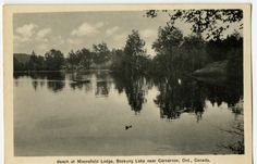
Photo description and source: Pintrest
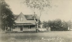
Moorefield Lodge, which burned in 1946, was a building 22 feet by 24 feet, erected in 1867 of 16 foot hand milled pine boards, an inch thick and 20 inches wide. Subsequent owner, Robert J. Moore opened Moorefield Lodge to accommodate travellers and lumbermen on the Gull River waters. Later it catered to tourists, thus the last piece of Stanhope real estate cultivated by Indians and the first owned by white men, gained fame for its summer hospitality. Source: In Quest of Yesterday by Nila Reynolds. Published by The Provisional County of Haliburton, Minden, Ontario 1973 p. 302